Let’s take minute to talk
mechanics. Let’s face it: if you’re into creating worlds for gaming, you’re
probably into the process as much as anything. I love geography and am
fascinated by geology (I love those How the Earth Was Made documentaries – they’re
like nerd crack!), which is part of the reason I enjoy creating worlds so much.
So, as I’ve created this world I’ve given a great deal of attention to the
physical structure of the land itself. These things require some thought.
It’s a few years old, but Rich
Burlew (the Giant in the Playground himself) gives an interesting discussion
of the logic of building the geography of a fantasy world. He emphasizes the inherent logic of how elevation,
water, and civilization work together.
After I read this, I went
back to my old maps of Kimatarthi, and I found that my treatment of the issue
was very similar to his in that there is an underlying logic for how everything
fits together. You can’t just slap together mountains and swamps and rivers and
cities and expect it to be a coherent thing. Kimatarthi itself has been
affected by plate tectonics, volcanism, and erosion. Its people are influenced
by climate, terrain, economics, and natural disasters, such as ravenous goblin
hordes.
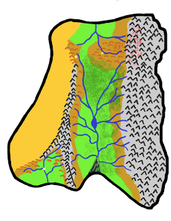
So, when I made an initial
sketch of the world, it was clear that the shape suggested two plateaus
separated by a long valley. I decided that the heights would be rather dramatic
and unlivable. Therefore, civilization has to exist at the lower elevations. Water
also flows down, and it seems that if there’s just one main valley almost all
of the smaller streams would eventually come together at a central river. I
decided to make this river run south until it fans out into a marsh and goes
over Land’s End.
The positions of the cities
are defined by this geography as well. Down south, Bryss benefits from substantial
glacial runoff, and is protected from the desert by mountains. Also, its higher
elevation keeps it a bit cooler.
In the east, Mudun can also
take advantage of water, elevation and arable land, but it’s vulnerable to
attack. Everything in the east was destroyed during the Goblin War, and that
whole region is still goblin territory.
Though everything west of
the Great Rift is mostly desert, the gap all the way up north is the only
passage to Bryss. Caravans making that long journey would have to outfit
themselves, and so Markaz developed into a trade hub at the last inhabitable
point beyond the Western Desert. These positions also suggest a relationship
among the cities that feeds into the larger political environment… but that’s
something I’ll explore later.
I have always enjoyed the
mental exercise that comes with figuring out why things are the way they are –
both in real life and in pretend. The nice thing about inventing a world,
though, is that you can follow an interesting idea and see where it leads. When
you run to a dead end, you can just think up another string that makes sense. I
once read that Tolkien reported that he felt that he was exploring a world more
than inventing one. And I can see how he’d feel that way.


